


BY DANIEL M. PEREZ
Journal Staff
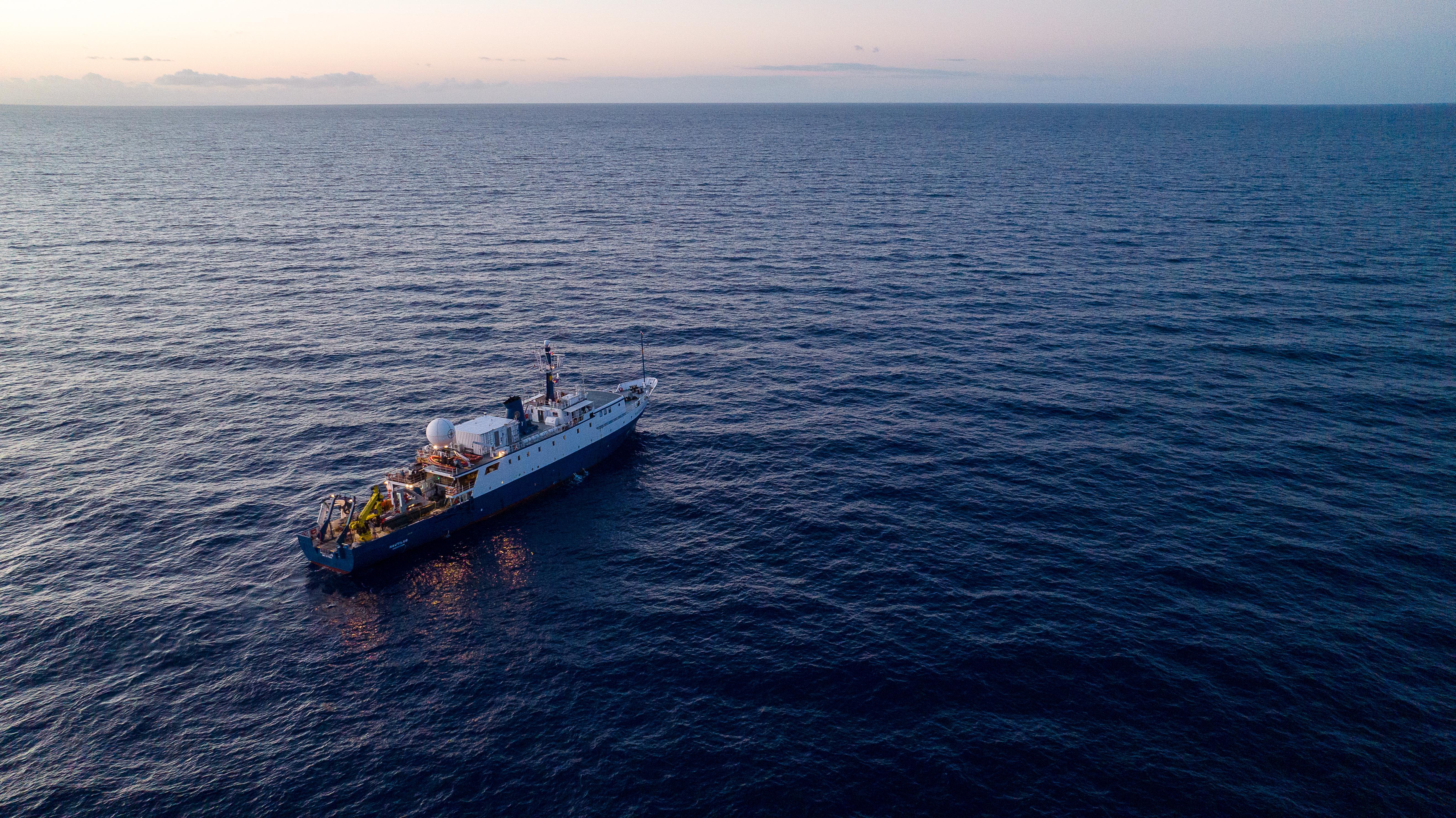
The Ocean Exploration Trust’s exploration vessel, Nautilus, departed Monday, June 29, to begin two back-to-back deep-sea research expeditions targeting unsurveyed waters east of the Mariana Trench.
Running from June through August, the missions aim to establish critical scientific baselines for habitat conservation, biodiversity, and marine critical minerals across 25% of the U.S. waters surrounding Guam and the Northern Mariana Islands.
The federal government is primarily funding the operations through NOAA Ocean Exploration via the Ocean Exploration Cooperative Institute, with additional financial backing from the Bureau of Ocean Energy Management. The first three-week expedition, designated NA179, will focus on the southeasternmost portion of U.S. waters around the NMI, while the second cruise, NA180, will map the northeastern most sectors of the region.
The expeditions will deploy high-tech mapping systems, remotely operated vehicles, and an autonomous underwater vehicle to study abyssal plain habitats and ancient seamounts, some of which exceed 167 million years old.
Robert Ballard, founder and chief executive officer of the Ocean Exploration Trust, said that the integration of deep-diving partner vehicles alongside organizational technologies makes exploring the deep ocean and learning about the planet "more efficient than ever before."
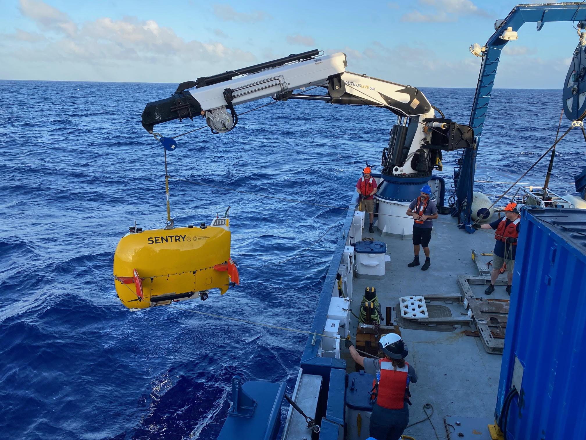
Although the region has a long history of maritime research, the vast majority of the deep seafloor east of the trench remains completely uncharacterized. The 2026 operations will expand upon summer 2025 missions, which completed nine successful remotely operated vehicle dives and six autonomous vehicle surveys. To optimize data collection, researchers are using a multi-platform surveying approach that pairs the primary vessel with an autonomous underwater vehicle called Sentry.
Sean Kelley, program manager of the autonomous underwater vehicle Sentry at the Woods Hole Oceanographic Institution, said that concurrent operations allow the team to move from traditional, linear exploration to a multi-pronged approach that combines the strengths of autonomous and remotely operated vehicles to "greatly increase the amount of data we can return to the scientific community from some of the most remote and extreme environments on the planet." Communication between the independent submersibles and the ship's engineering team will be maintained across significant distances via a wave-powered autonomous glider.
All geological, biological, and bathymetric data collected during the expeditions will be publicly archived without regulatory embargoes or access restrictions to support international scientific priorities and future environmental stewardship. Physical copies of the data, including physical hard drives, will be delivered directly to regional public and private institutional partners in Guam and the NMI.
The operational framework was structured with direct input from regional resource managers, scientists, and local stakeholders, embedding seven local educators, students, and environmental professionals from organizations including the University of Guam, Guam Community College, and the NMI Division of Fish and Wildlife. mbj
Journal Staff
The Ocean Exploration Trust’s exploration vessel, Nautilus, departed Monday, June 29, to begin two back-to-back deep-sea research expeditions targeting unsurveyed waters east of the Mariana Trench.
Running from June through August, the missions aim to establish critical scientific baselines for habitat conservation, biodiversity, and marine critical minerals across 25% of the U.S. waters surrounding Guam and the Northern Mariana Islands.
The federal government is primarily funding the operations through NOAA Ocean Exploration via the Ocean Exploration Cooperative Institute, with additional financial backing from the Bureau of Ocean Energy Management. The first three-week expedition, designated NA179, will focus on the southeasternmost portion of U.S. waters around the NMI, while the second cruise, NA180, will map the northeastern most sectors of the region.
The expeditions will deploy high-tech mapping systems, remotely operated vehicles, and an autonomous underwater vehicle to study abyssal plain habitats and ancient seamounts, some of which exceed 167 million years old.
Robert Ballard, founder and chief executive officer of the Ocean Exploration Trust, said that the integration of deep-diving partner vehicles alongside organizational technologies makes exploring the deep ocean and learning about the planet "more efficient than ever before."
Although the region has a long history of maritime research, the vast majority of the deep seafloor east of the trench remains completely uncharacterized. The 2026 operations will expand upon summer 2025 missions, which completed nine successful remotely operated vehicle dives and six autonomous vehicle surveys. To optimize data collection, researchers are using a multi-platform surveying approach that pairs the primary vessel with an autonomous underwater vehicle called Sentry.
Sean Kelley, program manager of the autonomous underwater vehicle Sentry at the Woods Hole Oceanographic Institution, said that concurrent operations allow the team to move from traditional, linear exploration to a multi-pronged approach that combines the strengths of autonomous and remotely operated vehicles to "greatly increase the amount of data we can return to the scientific community from some of the most remote and extreme environments on the planet." Communication between the independent submersibles and the ship's engineering team will be maintained across significant distances via a wave-powered autonomous glider.
All geological, biological, and bathymetric data collected during the expeditions will be publicly archived without regulatory embargoes or access restrictions to support international scientific priorities and future environmental stewardship. Physical copies of the data, including physical hard drives, will be delivered directly to regional public and private institutional partners in Guam and the NMI.
The operational framework was structured with direct input from regional resource managers, scientists, and local stakeholders, embedding seven local educators, students, and environmental professionals from organizations including the University of Guam, Guam Community College, and the NMI Division of Fish and Wildlife. mbj